Close Menu
  • Home
  • UNSUBSCRIBE
  • News
  • Lifestyle
  • Tech
  • Entertainment
  • Sports
  • Travel
Facebook X (Twitter) WhatsApp
Trending
  • How did animals survive the asteroid that killed the dinosaurs?
  • ‘We can identify these really early, before the clinical diagnosis’: Epigenetic markers may help explain why Native Hawaiians are aging faster
  • Catapult the cow: 6 medieval castles that were never conquered
  • China launches ‘human artificial embryos’ to space for the first time
  • NASA’s Psyche spacecraft beams back blue images of Mars on its way to a metal asteroid
  • Science news this week: Laotian ‘death jar’, climate change threatens rice crops, and an asthma drug treats tough cancer
  • DNA sequencing is rewriting our understanding of historic outbreaks, but it can’t tell the whole story
  • AI-generated images are making it impossible to distinguish truth from fiction. We need laws and AI watermarks to protect our shared reality.
Facebook X (Twitter) WhatsApp
Baynard Media
  • Home
  • UNSUBSCRIBE
  • News
  • Lifestyle
  • Tech
  • Entertainment
  • Sports
  • Travel
Baynard Media
Home»Lifestyle»Full moon helps paint vibrant, muddy ‘brushstrokes’ in Indonesian river — Earth from space
Lifestyle

Full moon helps paint vibrant, muddy ‘brushstrokes’ in Indonesian river — Earth from space

EditorBy EditorMay 5, 2026No Comments4 Mins Read
Share Facebook Twitter Pinterest LinkedIn Tumblr Reddit Telegram Email
Share
Facebook Twitter LinkedIn Pinterest Email

QUICK FACTS

Where is it? Rokan River, Sumatra, Indonesia [2.2294556537, 100.62990147]

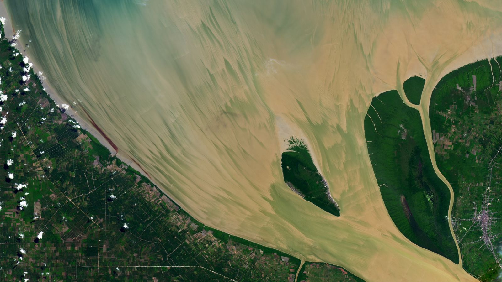
What’s in the photo? Brushstroke-like patterns of sediment painted by a high tide

Which satellite took the photo? Landsat 8

When was it taken? June 23, 2024

This beautiful satellite snap captured a series of “brushstroke-like patterns” that emerged in the mouth of an Indonesian river. The striking striations were triggered by a particularly high tide following a full “Strawberry Moon.”

The Rokan River is a roughly 220-mile-long (350 kilometers) waterway on Indonesia’s Sumatra island. The landmass covers around 170,000 square miles (440,000 square kilometers) in the Indian Ocean, making it the sixth-largest island on Earth.

The river runs from the Barisan Mountains in Sumatra’s west to the island’s north coast, where it drains into the Strait of Malacca. Here, the river morphs into a brackish estuary that flows on each side of Halang Island (photographed).


You may like

The Rokan River often has a yellow hue due to high levels of sand and silt in its waters. The sediment gets dragged up from the river’s floor, partially due to the constant rising and falling of the tide, according to NASA’s Earth Observatory.

In this image, the tide is on its way out, which causes the sediment to be slowly dragged out to sea. When viewed from above, these “brushstroke-like patterns” transform the river into what looks like an abstract painting, Earth Observatory representatives wrote.

Aerial photo of a river winding through the jungle on Sumatra

The Rokan River stretches for around 220 miles (350 km) through Sumatra’s rainforest and experiences a regular “tidal bore.”

(Image credit: JOKER/Jörg Löffke/ullstein bild via Getty Images)

When the photo was taken, the high tide was at its peak ‪—‬ up to 16 feet (5 meters) higher than low tide. The water was especially high because it was the day after the full “Strawberry Moon” rose in the sky, according to the Earth Observatory. (June’s full moon is nicknamed the Strawberry Moon because it coincides with the strawberry harvesting season in the Northern Hemisphere, not because of its color.)

The tidal range is greatest when there is a full moon because the sun and the moon are aligned in a straight line, so they gravitationally push and pull Earth’s oceans in sync. This is known as a “spring tide,” but it happens throughout the year.

Get the world’s most fascinating discoveries delivered straight to your inbox.

In addition to having a significant tidal range, the Rokan River is home to a regular tidal bore — a powerful surge of water that rushes upstream like a giant wave during high tides. This rare phenomenon occurs only in estuaries with a narrow mouth and a high tidal range.

A 2022 study revealed that the surge is responsible for transporting large amounts of sediment back up the river. If a bore occurred before the satellite photo was taken (which may or may not have happened), it could have stirred up some of the sediment streaks visible in the image.

All of this tidal action can have a significant impact on the estuary itself. A 2016 study compared satellite images of the estuary between 2000 and 2014, and found that the shoreline along the north of Halang Island (which clearly extends beyond the small landmass in the image) is growing at an average rate of 220 feet (67 m) per year.


A satellite photo showing a pair of rivers and a series of colorful lakes surrounding a giant white expanse Rainbow-colored phantom lakes

A 2011 astronaut photo shows off a series of colorful mini-lakes that appeared around the edge of a giant Namibian salt flat, known as the Etosha Pan, following a major flooding event.

Satellite photo of a large reservoir with bright green masses spreading across its surface Deadly, green sprawling mass

A 2022 satellite photo shows a thick mat of blooming algae and invasive aquatic plants spreading across the surface of the reservoir at South Africa’s Hartebeespoort Dam.

False-color satellite images of Earth taken by ESA's Biomass satellite 1st trippy ‘biomass’ snap

A 2025 first false-color image from ESA’s newly operational Biomass satellite shows off a unique perspective of the rainforests, grasslands and wetlands surrounding a winding river in Bolivia.


Source link

Share. Facebook Twitter Pinterest LinkedIn Tumblr Email
Previous ArticleEstrogen in both the male and female brain shapes responses to trauma, study suggests
Next Article ‘They weren’t burned by accident’: Mysterious green rocks discovered high in Pyrenees reveal ancient copper-smelting camp
Editor
  • Website

Related Posts

Lifestyle

How did animals survive the asteroid that killed the dinosaurs?

May 24, 2026
Lifestyle

‘We can identify these really early, before the clinical diagnosis’: Epigenetic markers may help explain why Native Hawaiians are aging faster

May 24, 2026
Lifestyle

Catapult the cow: 6 medieval castles that were never conquered

May 24, 2026
Add A Comment

Comments are closed.

Categories
  • Entertainment
  • Lifestyle
  • News
  • Sports
  • Tech
  • Travel
Recent Posts
  • How did animals survive the asteroid that killed the dinosaurs?
  • ‘We can identify these really early, before the clinical diagnosis’: Epigenetic markers may help explain why Native Hawaiians are aging faster
  • Catapult the cow: 6 medieval castles that were never conquered
  • China launches ‘human artificial embryos’ to space for the first time
  • NASA’s Psyche spacecraft beams back blue images of Mars on its way to a metal asteroid
calendar
May 2026
M T W T F S S
 123
45678910
11121314151617
18192021222324
25262728293031
« Apr    
Recent Posts
  • How did animals survive the asteroid that killed the dinosaurs?
  • ‘We can identify these really early, before the clinical diagnosis’: Epigenetic markers may help explain why Native Hawaiians are aging faster
  • Catapult the cow: 6 medieval castles that were never conquered
About

Welcome to Baynard Media, your trusted source for a diverse range of news and insights. We are committed to delivering timely, reliable, and thought-provoking content that keeps you informed
and inspired

Categories
  • Entertainment
  • Lifestyle
  • News
  • Sports
  • Tech
  • Travel
Facebook X (Twitter) Pinterest WhatsApp
  • Contact Us
  • About Us
  • Privacy Policy
  • Disclaimer
  • UNSUBSCRIBE
© 2026 copyrights reserved

Type above and press Enter to search. Press Esc to cancel.