
A “super” El Niño is now the most likely scenario from October 2026 to February 2027, according to a new forecast from the National Oceanic and Atmospheric Administration’s (NOAA) Climate Prediction Center.
El Niño is the warmer phase of the natural El Niño-Southern Oscillation (ENSO) climate cycle, a periodic shift in the waters of the tropical Pacific Ocean that supercharges global temperatures, in turn impacting weather patterns and crops worldwide.
Now, in a new ENSO forecast published May 14, NOAA estimates that there’s a 65% chance that the upcoming El Niño will be classified as strong or very strong starting in October, potentially placing it among the strongest in recorded history.
A “very strong” El Niño — meaning a 3.6-degree-Fahrenheit (2 degrees Celsius) rise in sea surface temperatures, and unofficially called a “super” El Niño — is now the most probable scenario for the October-to-February period.
There is also now an 82% chance that El Niño will arrive between now and July, with the phase looking highly likely to continue until February 2027. This is a roughly 20 percentage-point increase in certainty from NOAA’s April forecast that El Niño is right around the corner.
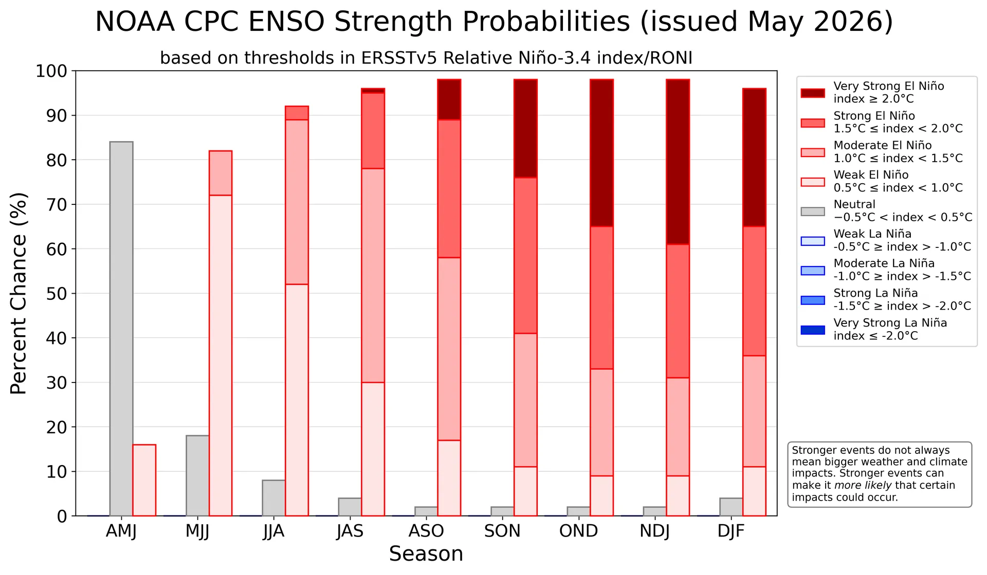
El Niño most likely to be “strong” or “very strong” from October to February.
(Image credit: NOAA Climate Prediction Center)
A “very strong” El Niño could wreak havoc
El Niño events occur every two to seven years, when shifts in wind and current patterns in the tropical Pacific Ocean cause sea surface temperatures to rise 0.9 F (0.5 C) above historical averages, resulting in profound knock-on effects on the global climate. The world is rapidly exiting the neutral phase.
The world’s most recent El Niño spanned from May 2023 to March 2024 and was partially responsible for 2024 being the hottest year on record. If the upcoming El Niño is strong or very strong, 2027 could surpass the previous record, according to Climate Brief’s State of the Climate assessment, published April 21.
In fact, the impending El Niño may itself break records. “Confidence is clearly shifting higher on potentially the biggest El Niño event since the 1870s,” Paul Roundy, a professor of atmospheric and environmental sciences at the University at Albany, wrote on X on May 5.
If a “super” El Niño does occur, it could rival the strongest on record: a catastrophic 1877 event that spurred the 1876-to-1878 global famine. The famine killed over 50 million people, or 3% of the world’s population at the time.
Although the social, political and economic landscapes have changed since the 1877-to-1878 El Niño, the upcoming event could still seriously threaten food, water and economic security around the world, Deepti Singh, head of the Climate Extremes and Impacts Lab at Washington State University, told The Washington Post.
“What is different now is that our atmosphere and oceans are substantially warmer than they were in the 1870s, which means the associated extremes could be more extreme,” Singh said.
More recent examples demonstrate the threat of strong and very strong El Niño phases. For example, an El Niño in 1997 to 1998 led to an estimated global economic loss of $32 billion to $96 billion.
NOAA ENSO forecaster Nathaniel Johnson recently told Live Science that a very strong El Niño would impact fisheries and crops, as well as heighten the risk of wildfires and hurricanes in parts of the world.
“You’ve got more people that are living in poverty already and if you get a reduction in crop yields because of drought or flooding [from El Niño] then that drives prices even higher,” Liz Stephens, a professor of climate risk and resilience at the University of Reading in the U.K., told the BBC. “So we’re looking at potentially quite huge humanitarian impacts this year, especially if the crisis in the Middle East continues.”
The next NOAA ENSO forecast will arrive June 11.