Close Menu
  • Home
  • UNSUBSCRIBE
  • News
  • Lifestyle
  • Tech
  • Entertainment
  • Sports
  • Travel
Facebook X (Twitter) WhatsApp
Trending
  • ‘Trash’ found deep inside a Mexican cave turns out to be 500-year-old artifacts from a little-known culture
  • Powerful Mother’s Day geomagnetic storm created radio-disrupting bubbles in Earth’s upper atmosphere
  • ‘The Martian’ predicts human colonies on Mars by 2035. How close are we?
  • Ram in the Thicket: A 4,500-year-old gold statue from the royal cemetery at Ur representing an ancient sunrise ritual
  • How much of your disease risk is genetic? It’s complicated.
  • Black holes: Facts about the darkest objects in the universe
  • Does light lose energy as it crosses the universe? The answer involves time dilation.
  • US Representatives worry Trump’s NASA budget plan will make it harder to track dangerous asteroids
Get Your Free Email Account
Facebook X (Twitter) WhatsApp
Baynard Media
  • Home
  • UNSUBSCRIBE
  • News
  • Lifestyle
  • Tech
  • Entertainment
  • Sports
  • Travel
Baynard Media
Home»Lifestyle»Iran’s folded rocks: The crumpled mountains at the intersection of Asia and Europe
Lifestyle

Iran’s folded rocks: The crumpled mountains at the intersection of Asia and Europe

EditorBy EditorApril 18, 2025No Comments3 Mins Read
Share Facebook Twitter Pinterest LinkedIn Tumblr Reddit Telegram Email
Share
Facebook Twitter LinkedIn Pinterest Email

QUICK FACTS

Name: “Folded rocks” of the Aladaghlar Mountains

Location: Northwest Iran

Coordinates: 37.126276036681965, 47.61930020667193

Why it’s incredible: The landscape looks crumpled and folded from above.

Iran’s folded rocks are rugged mountain ridges and valleys to the southwest of the Caspian Sea. They are an extension of the Greater Caucasus mountain belt, which also stretches along Russia’s border with Georgia and Azerbaijan.

The folded rocks sit at the intersection of Asia and Europe, where major tectonic forces converge. The rocks are formed of countless sedimentary layers, which were upturned and creased into the landscape we see today during the initial collision between the Arabian and Eurasian tectonic plates. The timing of this collision is hotly debated, with estimates ranging from 10 million to 50 million years ago.

“A tectonic collision between Eurasia and Arabia over millions of years compressed these colorful rock layers, bending them into large folds,” NASA officials wrote on the social platform X in January 2024.


You may like

The Arabian and Eurasian plates are still converging, and recent research indicates a chunk of oceanic crust that separated the two plates before they collided is now being torn apart under Iraq and Iran. The Neotethys oceanic plate appears to be pulling the region down from below, resulting in an unusual accumulation of sediment at the surface.

Related: North America is ‘dripping’ down into Earth’s mantle, scientists discover
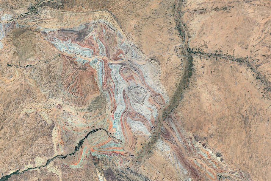
Satellite image of the folded rocks in northwestern Iran in 2025.

Iran’s folded rocks captured with a satellite in 2025. The green line curving down from the top of the image is the Qezel Ozan River. Towards the top of the image, a line cutting through the folded rocks shows the Zanjan-Tabriz freeway (Freeway 2). (Image credit: Imagery ©2025 Airbus, CNES / Google maps)

Iran’s folded rocks are colorful, with vibrant terracotta, greenish and blueish bands that are the result of different sedimentary layers deposited over time. These layers were eroded over millions of years after the initial tectonic collision, exposing the underlying rocks’ alternating colors and textures.

Satellite images of the folded rocks reveal the extent to which the landscape was bunched together over the eons. Scientists at NASA’s Jet Propulsion Laboratory colored one such image with infrared to show the various rock layers, as well as vegetation and the human-built Zanjan-Tabriz freeway, which cuts through the folded rocks and connects the cities of Tehran and Tabriz.

Get the world’s most fascinating discoveries delivered straight to your inbox.

Another satellite image from NASA’s Earth Observatory highlights the intricacy of Earth’s surface in this region and shows the Qezel Ozan River, which hugs the southeast corner of the folded rocks and supplies water for agriculture in the area.


Discover more incredible places, where we highlight the fantastic history and science behind some of the most dramatic landscapes on Earth.

Source link

Share. Facebook Twitter Pinterest LinkedIn Tumblr Email
Previous ArticleTSMC’s upcoming 2nm microchip is a breakthrough. Here’s what it means for the future of tech — from AI to smartphones.
Next Article Weird repeating nova explosion is one of the hottest blasts ever seen
Editor
  • Website

Related Posts

Lifestyle

‘Trash’ found deep inside a Mexican cave turns out to be 500-year-old artifacts from a little-known culture

May 26, 2025
Lifestyle

Powerful Mother’s Day geomagnetic storm created radio-disrupting bubbles in Earth’s upper atmosphere

May 26, 2025
Lifestyle

‘The Martian’ predicts human colonies on Mars by 2035. How close are we?

May 26, 2025
Add A Comment

Comments are closed.

Categories
  • Entertainment
  • Lifestyle
  • News
  • Sports
  • Tech
  • Travel
Recent Posts
  • ‘Trash’ found deep inside a Mexican cave turns out to be 500-year-old artifacts from a little-known culture
  • Powerful Mother’s Day geomagnetic storm created radio-disrupting bubbles in Earth’s upper atmosphere
  • ‘The Martian’ predicts human colonies on Mars by 2035. How close are we?
  • Ram in the Thicket: A 4,500-year-old gold statue from the royal cemetery at Ur representing an ancient sunrise ritual
  • How much of your disease risk is genetic? It’s complicated.
calendar
June 2025
M T W T F S S
 1
2345678
9101112131415
16171819202122
23242526272829
30  
« May    
Recent Posts
  • ‘Trash’ found deep inside a Mexican cave turns out to be 500-year-old artifacts from a little-known culture
  • Powerful Mother’s Day geomagnetic storm created radio-disrupting bubbles in Earth’s upper atmosphere
  • ‘The Martian’ predicts human colonies on Mars by 2035. How close are we?
About

Welcome to Baynard Media, your trusted source for a diverse range of news and insights. We are committed to delivering timely, reliable, and thought-provoking content that keeps you informed
and inspired

Categories
  • Entertainment
  • Lifestyle
  • News
  • Sports
  • Tech
  • Travel
Facebook X (Twitter) Pinterest WhatsApp
  • Contact Us
  • About Us
  • Privacy Policy
  • Disclaimer
  • UNSUBSCRIBE
© 2025 copyrights reserved

Type above and press Enter to search. Press Esc to cancel.